
Explore Dartmoor’s Spectacular Walking and Hiking Routes
Immerse yourself in the breathtaking beauty of Dartmoor with our personal choice of walking and hiking routes, starting from Wray Valley or nearby locations. Whether you’re a leisurely stroller or an avid hiker, we have a variety of trails to suit your preferences. We’ve many more ideas for walks than we’ve highlighted here. Take advantage of our maps, route guides, and the option to hire a local guide to enhance your experience. Remember to book in advance if you’d like a guided walk or to take part in our navigation skills course.
Short(ish) Walks (1 – 3 hours)
Wray Cleave Circular
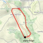
Distance: 3 km
Time: 1 hour
Ascent: 47 m
Difficulty: Easy
Start: Wray Valley
Route Description
An exploration of Wray Cleave, the ancient woodland on the hillside opposite us. The basic route follows the obvious path along the bottom of the wood to the remains of Wray Mine and then returns on the Wray Valley Trail. There are options to climb to the top of the wood to explore the crags and get a view across to Haytor. Great for an afternoon or evening stroll to stretch the legs after a long drive. The start can be a little muddy.
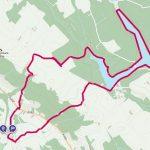
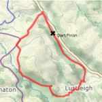
Bovey Valley Woods
Distance: 6 km
Time: 1:45 hours
Ascent: 200 m
Difficulty: Easy to Moderate
Start: Lustleigh or Pullabrook Car Park
Route Description
A short walk from Lustleigh to the scenic Hisley Bridge at the bottom end of Lustleigh Cleave. There is a steep climb from the river to Heavens Gate, but otherwise the walk is easy going. The walk can be shortened by 1km and the climb reduced by returning via Rudge as shown. Alternative start point at Pullabrook car park near Drakeford Bridge. Find out more about the Bovey Valley Woods.
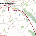
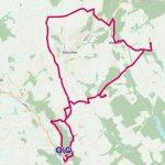
North Bovey Circular
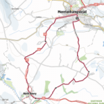
Distance: 7.5 km
Time: 2 hours
Ascent: 150 m
Difficulty: Moderate
Start: Moretonhampstead
Route Description
A walk across undulating farmland between Moretonhampstead and North Bovey following the Dartmoor Way. Refreshments available at the Ring of Bells in North Bovey and in Moretonhampstead. Lovely picnic spot beside the river in North Bovey.
Teign Valley and Fingle Bridge
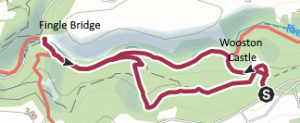
Distance: 6.5 km
Time: 2 hours
Ascent: 200 m
Difficulty: Easy to Moderate
Start: Wooston Castle Car Park
Route Description
A lovely walk through shady woods beside the River Teign in the steep sided Teign Valley. The start point in the Hillfort Car Park is the closest to us and avoids a long drive round to Fingle Bridge. Refreshments at the Fingle Bridge Inn.
Moreton Meander
Distance: 9 km approx. 2:30 hours
Ascent: 80 m
Difficulty: Easy
Start: Wray Valley
Route Description
A pleasant stroll up the Wray Valley Trail to explore Moretonhampstead. There is a town trail that can be purchased from the Tourist Information Office and we have a copy you can borrow. Find out about the Sparrowhawk, the connection to WH Smith, the Sentry and the Almshouses. Visit the pubs, shops and cafes.
Lustleigh Linger
Distance: 9 km
Time: 2:30 hours
Ascent: 80 m
Difficulty: Easy
Start: Wray Valley
Route Description
A pleasant stroll down the Wray Valley Trail to explore Lustleigh. Optional extension to see Kelly Mine, which is normally open on Wednesday and Sunday (<1 km each way). The route takes in the War Memorial, the Community Orchard with May Queen Rock, Wrayland hamlet, the Wray Brook and returns to the village green with the pub, church, tea shop, village shop and art gallery
Haytor & Hound Tor
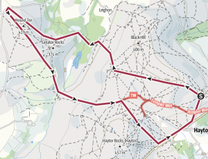
Distance: 8.2 km
Time: 2:15 hours
Ascent: 240 m
Difficulty: Moderate
Start: Haytor or Hound Tor
Route Description
After you’ve climbed Haytor why not go for a longer walk. Imagine this part of the moor teaming with quarry workers and horse drawn trams. Visit the enchanting Haytor quarry and follow the granite tramway to Holwell Quarry. See if you can find the Beehive Hut where the quarry workers took shelter from the weather. Cross the Becka Brook and climb the other side of the valley to Hound Tor and the medieval village. In May, the bluebells on Holwell Lawn are a spectacular sight and give off a wonderful heady scent. At Hound Tor you may be lucky and be able to get a calorie laden snack from the mobile van before heading back to the start.
Blackingstone Rock Circular

Distance: 8.5 km
Time: 2:45 hours
Ascent: 320 m
Difficulty: Moderate
Start: Wray Valley
Route Description
On a clear day Blackingstone Rock gives magnificent views of the high moor. From Haytor to Hound Tor (East Dartmoor), Hangingstone Hill right round to Yes Tor and High Willhays. A flight of very steep steps cut in the granite by the Victorians lead to the summit where several rock basins have formed in the flat surface.
Legend has it that King Arthur and the Devil were having an argument. King Arthur took his stand on the hill where the Blackingstone now stands and the Devil on the hill where Hel Tor is today. It was decided that the best way to settle this dispute was by hurling a mighty quoit at each other. As the quoits hit the ground they immediately turned to stone forming Blackingstone Rock and Hel Tor.
Half Day Hikes (3 – 4 hours)
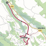
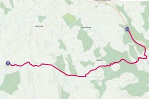
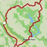
Three Reservoirs and Kelly Mine
Distance: 10.4 km
Time: 3:15 hour
Ascent: 230 m
Difficulty: Moderate
Start: Lustleigh
Route Description
The route is shown starting at the end of the Wray Valley Trail in Lustleigh but it can of course be made longer by starting here at Wray Valley or much shorter by starting at the Reservoirs Car Park. Do not attempt to walk down the A382 to start the walk at Wray Barton as this is unsafe.
The ascent and descent up through the woods from the A382 to and from the reservoirs is very steep and can be slippery if muddy.
On Wednesdays and Sundays it is usually possible to take a look around Kelly Mine. Allow at least 1 hour for this!
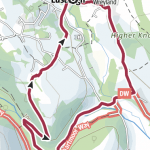
Fingle Bridge and Castle Drogo
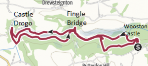
Distance: 12.8 km
Time: 4 hours
Ascent: 338 m
Difficulty: Moderate
Start: Fingle Bridge or Castle Drogo
Route Description
An extension to the Teign Valley to Fingle Bridge walk. There is a steep cliimb up from Fingle Bridge and the high level path is quite narrow. It is possible to visit the impressive Castle Drogo (National Trust) if you time.
The walk can be started from Fingle Bridge or Castle Drogo. The car park at Fingle Bridge is the other side of the narrow bridge – not on the road leading down to it. The car park at Castle Drogo is owned by the National Trust. Refreshments at Fingle Bridge Inn and Castle Drogo.
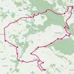
Lustleigh Cleave Circular
Distance: 11.5 km
Time: 4 hours
Ascent: 250 m
Difficulty: Moderate
Start: Wray Valley
Route Description
A beautiful walk through Lustleigh Cleave (Devon word for wooded river valley). The walk can be done in either direction but we prefer to head north up the Wray Valley Trail to Wray Barton. That way we get the steep climb up the Manaton road out of the way early on, and have a stop off in Lustleigh for refreshments to look forward to! The route can also be cycled on a mountain bike – but it has steep and rough tracks!
Full Day Treks (4+ hours)
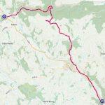
Warren House to Wray Valley (by Bus)
Distance: 16.5 km
Time: 5:45 hours
Ascent: 445 m
Difficulty: Moderate
Start: Warren House Inn
Route Description
A classic linear walk taking in a range of sights from the high moor and tin mining to myths and legends and temperate rainforest. In Summer the 171 bus goes past Wray Valley at about 9:35 am via Princetown to Tavistock. Take this to the Warren House Inn.
From the Warren House you head east passing the remains of Vitifer Tin Mine and carry on to the remains of Grimspound neolithic village. Over Hameldown ridge to Natsworthy Gate and on to the legendary “Jay’s Grave”. Continuing east to Hayne Down and Bowerman’s Nose before descending to the Kestor Inn in Water. From there enter the temperate rainforest of Lustleigh Cleave, cross the River Bovey and ascend to Heavens Gate. Descend to the Community Orchard in Lustleigh and the Cleave Inn to brace yourself for the final push along the Wray Valley Trail.
Haytor from Lustleigh
Distance: 19.4 km
Time: 6:20 hours
Ascent: 762 m
Difficulty: Strenuous
Start: Lustleigh
Route Description
A mix of moorland and rainforest. It is highly recommended that you start this walk in Lustleigh to avoid the 3.5km each way along the Wray Valley Trail! The route can be done in either direction. From Lustleigh cross the River Bovey at Hisley Bridge and ascend via Trendlebere Down to Black Hill, Smallacombe Rocks and Haytor. Return via the tramway to Holwell Tor, crossing the Becka Brook to ascend to Hound Tor. Continue to Bowerman’s Nose and the Kestor Inn at Water. Descend into Lustleigh Cleave and return to the Cleave Inn in Lustleigh.
Blackingstone, Heltor and Marden Down
Distance: 15.9 km
Time: 5:15 hours
Ascent: 619 m
Difficulty: Moderate – Strenuous
Start: Wray Valley
Route Description
Some steep ascents and descents make this route more challenging than most or our other routes.
Take the path opposite the house and walk along the bottom of Wray Cleave wood to Pepperdon Lane. Cross Pepperdon Down to the minor road and the viewpoint at Blackingston Rock. Follow the minor road north east to Heltor Rock. Return via Westcott and cross the B3212 to Marden Down and explore the stone circles, cairns and WWII engineering training earthworks.
Return on the minor road past Pepperdon Down to the path that leads to the remains of Lewdown Cottages and continue along the top of Wray Cleave. Steep descent to the A382 and Wray Valley.
Wray Valley to Bridford
Distance: 19 km
Time: 5:5 – 6 hours
Ascent: 512 m
Difficulty: Moderate – Moderate
Start: Wray Valley
Route Description
A good pub walk for when the weather is not good enough for the high moor.
Take the path opposite the house and ascend steeply to the top of Wray Cleave. Continue to climb less steeply through Pepperdon Down and on to Blackingstone Rock for a spectacular view of Dartmoor. Follow road and paths to the Bridford Inn. Return via the conifer plantation around the reservoirs. Descend steeply through rainforest to the fascinating Kelly Mine.
Next highlight is the picturesque thatched hamlet of Wreyland, and into Lustleigh. Stop for refreshments before returning on the Wray Valley Trail.
Fingle Bridge – Dogmarsh Bridge (by Bus)
Distance: 12.6 km
Time: 4.5 hours
Ascent: 351 m
Difficulty: Moderate
Start: Bus 178 to Dogmarsh Bridge
Route Description
This route can be done in either direction but it is recommended that you catch the bus to the start and walk back. Get off by the Mill End Hotel. Walk beside the river to Fingle Bridge and a steep climb to Cranbrook Castle. A gentle walk back with stunning views to Moretonhampstead to pick up the Wray Valley Trail.
Hire a Guide or Join a Navigation Course
Enhance your Dartmoor walking experience by enlisting the knowledge of a local guide or participating in our navigation course.
Our expert guides offer unique insights into the region’s history, flora, and fauna, ensuring a remarkable and immersive adventure. Whether you’re a beginner or an experienced hiker, our guides will tailor the experience to suit your interests and skill level.
If you’re keen to improve your navigation skills, our navigation courses are an excellent opportunity to gain confidence in map reading, compass use, and route planning. With personalised instruction, you’ll be well-equipped to explore Dartmoor’s vast network of trails independently.
Please contact us in advance to enquire about hiring a guide or joining our navigation course. We’re here to help you create an enriching and memorable Dartmoor walking experience.

Don’t wait – plan your dream getaway today!